
Waioweka River
| Waioweka River | |
|---|---|
 Waioeka River from the Oponae Bridge | |
 Route of the Waioweka River | |
.png) Mouth of the Waioweka River  Waioweka River (North Island) | |
| Location | |
| Country | New Zealand |
| Physical characteristics | |
| Source | Confluence of the Koranga River and Kahunui Stream |
| • coordinates | 38°23′48″S 177°17′17″E / 38.39663°S 177.28814°E |
| Mouth | |
• location | Pakihikura Harbour |
• coordinates | 38°00′05″S 177°16′45″E / 38.00135°S 177.27918°E |
| Basin features | |
| Progression | Waioweka River → Pakihikura Harbour → Bay of Plenty → Pacific Ocean |
| Tributaries | |
| • left | Wairato Stream, Oponae Stream, Waiata Stream, Tauranga Stream, Mangaoira Stream, Omuraaka Stream, Ruahema Stream, Otakoi Stream |
| • right | Mangakoiti Stream, Okarewa Stream, Okuraata Stream, Opato Stream, Omaukora Stream, Ōhau Stream, Papepeti Stream, Mangapumarumaru Stream, Owhiritoa Stream, Matahanea Creek, Cruen Creek, Marawaiwai Stream |
| Waterfalls | Hells Gate Rapids |
| Bridges | Oponae Bridge, Tauranga Bridge, Waioweka River Bridge |
The Waioeka River is in the eastern Bay of Plenty Region of New Zealand's North Island. Its name was officially changed to Waioweka River in 2024.[1] The river flows northwards for 65 kilometres (40 mi) from Te Urewera National Park to reach the sea at Ōpōtiki. It shares its estuary with the Ōtara River.
History
[edit]The area around the Waioeka valley was the scene of fighting during the New Zealand wars.
Gallery
[edit]-
 2,600 sheep on the road, Waioeka Gorge, after a 97-kilometre (60 mi) drive
 -
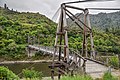
 Oponae Bridge
 -
 Tauranga Bridge, a historic bridge in the Waioweka Gorge
 -
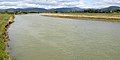 The Waioweka River near Ōpōtiki
 -
 The Waioweka River Bridge near Ōpōtiki
.jpg)


See also
[edit]References
[edit]- ^ "Waioweka River". New Zealand Gazetteer. Land Information New Zealand. Retrieved 5 August 2024.