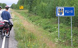
Yli-Ii
Appearance
Yli-Ii | |
|---|---|
Former municipality | |
| Yli-Iin kunta Överijo kommun | |
 | |
 Location of Yli-Ii in Finland | |
| Coordinates: 65°22′20″N 025°50′25″E / 65.37222°N 25.84028°E | |
| Country | Finland |
| Region | Northern Ostrobothnia |
| Sub-region | Oulu Arc sub-region |
| Charter | 1924 |
| Government | |
| • Municipal manager | Pekka Tolonen |
| Area | |
• Total | 793.27 km2 (306.28 sq mi) |
| • Land | 769.15 km2 (296.97 sq mi) |
| • Water | 24.12 km2 (9.31 sq mi) |
| Population (31 December 2012)[2] | |
• Total | 2,179 |
| Time zone | UTC+2 (EET) |
| • Summer (DST) | UTC+3 (EEST) |
| Website | www.yli-ii.fi |
Yli-Ii (Swedish: Överijo) was a municipality of Finland. It was located in the province of Oulu and was part of the Northern Ostrobothnia region. Alongside Haukipudas, Kiiminki and Oulunsalo municipalities it was merged with the city of Oulu on 1 January 2013. The municipality had a population of 2,179 (31 December 2012)[2] and covered an area of 793.27 square kilometres (306.28 sq mi) of which 24.12 km2 (9.31 sq mi) is water.[1] The population density was 2.8330/km2 (7.3374/sq mi).
The municipality was unilingually Finnish.[3]
Yli-Ii is probably best known from a pre-historical museum called Kierikkikeskus.
References
[edit]- ^ a b "Area by municipality as of 1 January 2011" (PDF) (in Finnish and Swedish). Land Survey of Finland. Retrieved 9 March 2011.
- ^ a b "VÄESTÖTIETOJÄRJESTELMÄ REKISTERITILANNE 31.1.2012" (in Finnish and Swedish). Population Register Center of Finland. Archived from the original on 3 October 2013. Retrieved 11 February 2014.
- ^ "Population according to language and the number of foreigners and land area km2 by area as of 31 December 2008". Statistics Finland's PX-Web databases. Statistics Finland. Archived from the original on 12 June 2009. Retrieved 29 March 2009.
External links
[edit]![]() Media related to Yli-Ii at Wikimedia Commons
Media related to Yli-Ii at Wikimedia Commons
- Municipality of Yli-Ii – Official site (in Finnish)


